Breaking News Large Hurricane Melissa Category 5 Forming See More
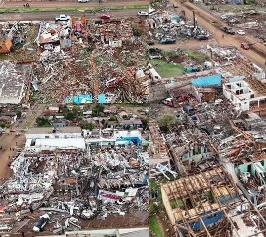
As we reported earlier, Melissa ranks as the most powerful hurricane ever to make a direct strike on Jamaica.
Across the broader Atlantic, Melissa stood out for several extraordinary reasons. It matched the record for the strongest hurricane to make landfall anywhere in the Atlantic basin, with sustained winds reaching 185 mph. With a central pressure of 892 mb, Melissa also equaled the 1935 Labor Day Hurricane as the most intense landfalling storm on record.
In addition, Hurricane Hunter aircraft, which collect vital data by flying directly into storms, recorded an instantaneous wind gust of 252 mph just above the ocean surface before Melissa made landfall. For comparison, this reading falls only slightly below the world record for the highest wind gust ever documented in a tropical cyclone: 253 mph, observed during Cyclone Olivia’s impact on Western Australia in April 1996.
A Category 5 rating describes sustained winds of at least 157 mph on the Saffir-Simpson Hurricane Wind Scale. It signals the potential for catastrophic structural damage, prolonged power failures, and areas that may be difficult to inhabit for weeks or months. The category does not measure every hazard. Storm surge, rainfall, flash flooding, and landslides can be deadly far from the point of landfall.
For an island such as Jamaica, preparation involves more than boarding windows. Emergency managers must consider coastal communities, mountain roads, hospitals, shelters, ports, and communications. Residents in evacuation zones need to follow local instructions because conditions can deteriorate before the eye of the storm reaches land.
Hurricane Hunter observations are crucial when a storm intensifies quickly. Aircraft measure pressure, wind, temperature, and moisture inside the system, giving forecasters information that satellites cannot capture on their own. Those measurements help refine warnings and provide a clearer picture of the storm’s structure.
Wind records require careful interpretation. An instantaneous gust measured above the surface is different from the one-minute sustained wind used for hurricane categories. Both observations demonstrate extreme conditions, but they should not be presented as identical measurements. Location, altitude, and instrument method all matter when records are compared.
After landfall, the danger continues. Floodwater may conceal debris and damaged roads, downed power lines can remain energized, and weakened buildings may collapse. Clean water, medicine, and reliable communication often become immediate priorities. Relief agencies also need access to communities cut off by landslides or flooding.
People following the storm from outside the affected region can help by using official forecast products and verified emergency information. Dramatic videos may be old or recorded in another country. The National Hurricane Center and local disaster agencies provide dated advisories, maps, and safety instructions that are more useful than an undated social media alert.
Melissa’s reported intensity places it among the most remarkable storms in Atlantic history. The lasting measure of the disaster, however, is the effect on people and communities. Accurate warnings, early evacuation, resilient infrastructure, and sustained recovery support remain the most important tools for reducing that harm.
Recovery from a storm of this scale extends long after the wind weakens. Families may face destroyed homes, lost income, damaged schools, interrupted health care, and emotional trauma. Rebuilding decisions can reduce future risk through stronger construction, restored natural buffers, reliable shelters, and improved warning systems. International attention is often greatest during landfall, but affected communities need sustained assistance in the months that follow. Documenting both the meteorological records and the human recovery gives a fuller account of what a Category 5 hurricane means for an island and for the people who call it home.